Whitechapel – Housing and living conditions
Hello and welcome, today we will be studying content for Paper 1 Section A: Whitechapel, c1870–c1900: crime, policing and the inner city.

Did everyone live in the same conditions and style of house in Whitechapel?
The answer is no. Most people living in Whitechapel in the late 19th century lived in poor conditions. A few enjoyed a more comfortable standard of living.
Key facts:
In 1881, Whitechapel’s 30,709 people lived in 4,069 houses – on average 7.5 in each.
Whitechapel’s population density was 189 per acre compared to 45 in London as a whole.

Question
- Study the section of Charles Booth’s poverty map covering Whitechapel and surrounding area.

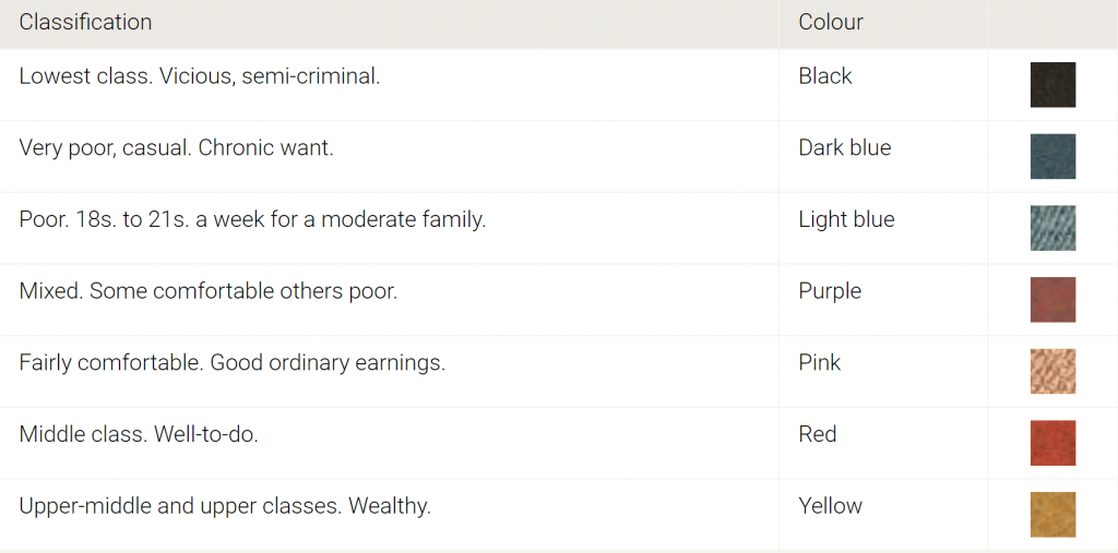
a) Find Whitechapel Road. What can you infer about the people living on Whitechapel Road?
b) Where are the dark blue areas mainly located?
c) Are there any yellow areas recorded on the map?
d) Find a square of housing surrounded on the outside by red with blue / black on in the inside. What can you infer about Whitechapel from this?
e) Using the map what was the main class of people living in Whitechapel?
f) Look at the areas surrounding Whitechapel – are they similar or different to Whitechapel?
Who made the map?
Charles Booth was a British shipowner, social researcher and reformer, best known for his innovative philanthropic studies on working-class life in London towards the end of the 19th century . He commissioned poverty maps between 1886 and 1903, as part of his ground-breaking study into the lives of ordinary Londoners. It was called ‘Inquiry Into the Life and Labour of the People in London’. His study included families and residents living across London. Streets were colour-coded to show levels of wealth and poverty.
Philanthropic: seeking to promote the welfare of others.
The poorest areas
As you studied the map you would have noticed that there were many streets tightly packed together. Many houses in Whitechapel were hundreds of years old and badly built that had deteriorated over time. Houses had been extended, with no planning permission or building regulations. In the poorest streets people lived in overcrowded lodging houses. The 1871 census records over 900 lodgers living in just 31 houses in one street. Rooms would have been in very bad condition. Lice would live in the plaster lined walls, rats freely run around and poor ventilation. There were no inside toilets. People used buckets in their rooms or shared outside facilities. Streets were very narrow, in some places a man could stand in between two houses and touch both.
Overcrowding: More people living in a space or area than is thought safe.
Lodging house: building that has been divided into rooms, each let to different people. Some rooms were let for 8 hours allowing the owner to increase profits.
Rookeries: slum area that suffered from overcrowding and poor sanitation.
Question
2. Return to Charles Booth’s map.
a) Identify the poorest areas. Streets coloured in black to show extreme poverty include Flower and Dean Street, Fournier Street – all located off Commercial Street.
Housing improvements
During the late 19th century the government introduced a range of laws to improve living conditions. The main law passed was the Artisans’ and Labourers’ Dwellings Improvement Act 1875.
Peabody Estate
It was a first step in improving housing in a rookery within Whitechapel. George Peabody bought an area of land from the government as part of its slum clearance programme in 1875. It was agreed that the slum would be replaced with model housing. Peabody ordered the demolition of the rookery. It was replaced with 286 flats in 1881. Tenants were charged reasonable rates for a better standard of living. Weekly rents started at three shillings (15p) for a one room flat and went up to six shillings (30p) for three rooms.
Slum: poor area of a city with no facilities
Model housing: Improved and high standard of housing
Tenant: Some one who rents
Summary
Question
2. Copy the diagram below. Using the information from this page create a pyramid of knowledge.
* Core knowledge: What are the five things you have to know to understanding housing – one for each block.
* Top fact: One fact that summaries your learning
* The rest: Facts you think are important.

Well done you have completed your learning today.
What to know more?
Grades 9- 7
Explore the differences in wealth of the population of Whitechapel using the interactive map. The map was created by Charles Booth. He led a social survey of London during this period.
https://booth.lse.ac.uk/map/13/-0.1250/51.5156/100/0
Discover more about the survey
https://booth.lse.ac.uk/learn-more/what-was-the-inquiry
More details about living conditions.